Data Gap Identification and Data Improvement - March 2026 Update

The GSP Updates, Data Gaps, and Refinements Project enhanced the GSA's understanding of the Subbasin's hydrogeology and groundwater users, supporting updates to the Groundwater Sustainability Plan (GSP) and effective groundwater management.
The Wyandotte Creek GSA (GSA) completed a comprehensive suite of activities to strengthen the technical foundation of the GSP and fill data gaps on the Subbasin's groundwater conditions. By expanding the monitoring network and refining technical tools, the GSA significantly improved its ability to evaluate basin conditions and respond to Department of Water Resources (DWR) recommended corrective actions in the GSP Periodic Evaluation. Thank you to everyone who collaborated on this project.
Key Accomplishments
Monitoring Network & Technical Refinements
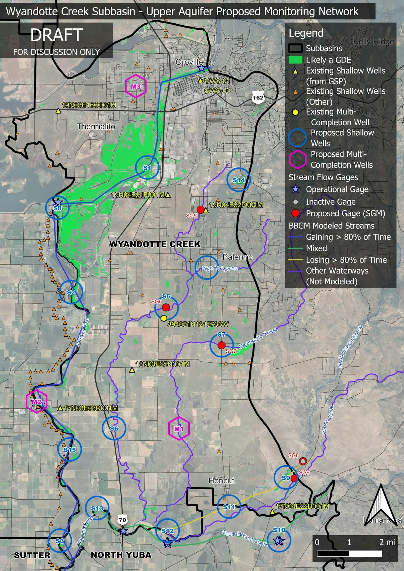
New Monitoring Infrastructure: To address data gaps identified in the GSP, the project team installed new physical infrastructure across the subbasin:
- Multi-Completion Monitoring Well: One new multi-completion well was installed in early 2026, providing critical data on groundwater conditions across multiple areas.
- Shallow Monitoring Wells & Stream Gages: Four new shallow monitoring wells and five new stream gages were installed to improve our understanding of groundwater-surface water interactions.
- Technical Design & Planning: All sites were selected based on the Hydrologic Conceptual Model (HCM) and hydrogeologic conditions to ensure maximum data impact.
Community Monitoring Program: The GSA established a Community Monitoring Program to supplement the dedicated network with data from local domestic wells.
- Program Roadmap: A formal Community Monitoring Plan was developed, outlining strategies for future outreach and data management to continue growing this network.
- Pilot Installation: The project successfully installed monitoring equipment at a volunteer domestic well to track water levels in residential areas.
- Interactive Data Visualization: A web-based mapping tool is now available, allowing stakeholders to visualize monitoring locations across the Subbasin.
Sustainable Management & Regulatory Compliance
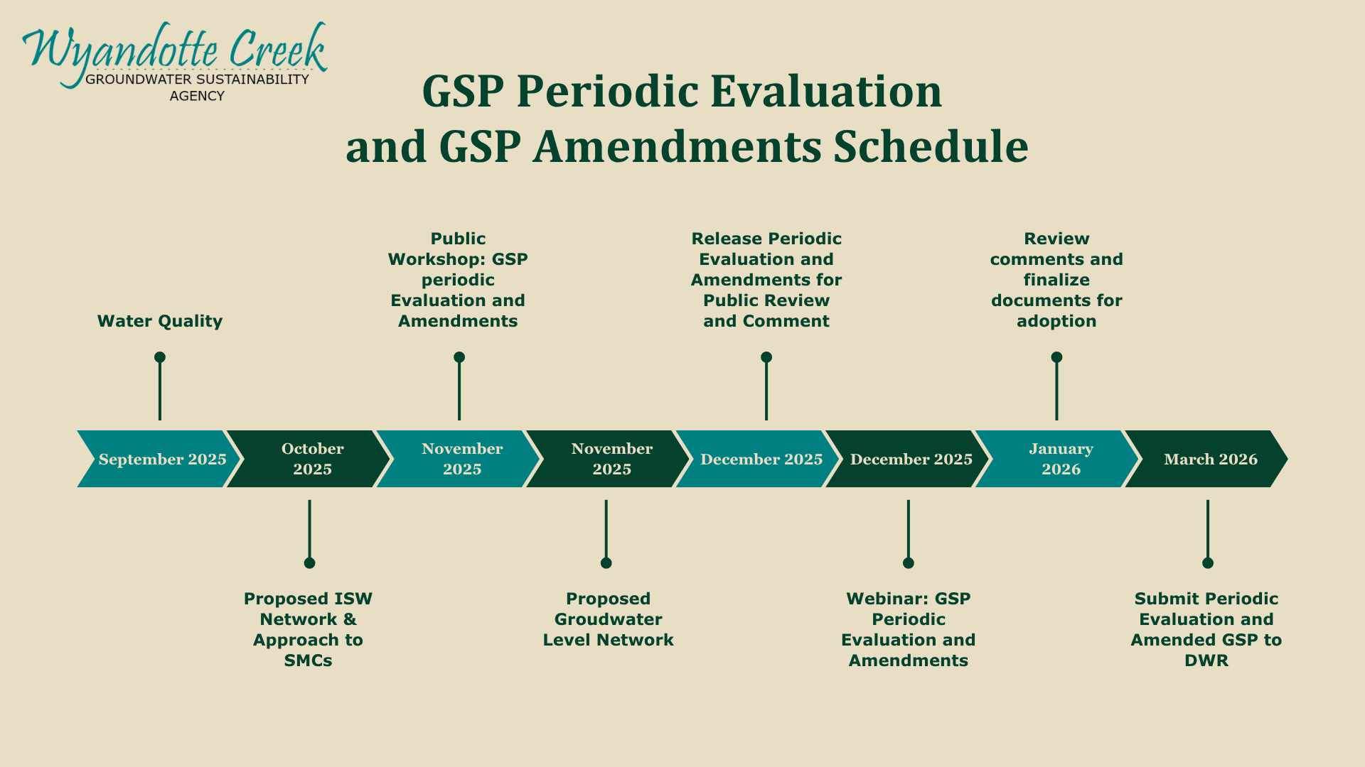
GSP Amendments & Periodic Evaluation: In response to DWR's recommendations, the GSA conducted extensive technical work to refine its management criteria:
- Interconnected Surface Water (ISW): The GSA refined the approach to the Sustainable Management Criteria (SMC) for ISW, using updated monitoring data and groundwater levels to support the development of measurable objectives and minimum thresholds for ISW.
- Draft GSP Amendments: Draft amendments to the GSP were prepared and made available for public review in March 2026.
- Five-Year Periodic Evaluation: Preparation for the first Five-Year Periodic Evaluation (due January 2027) is underway, with draft materials incorporated into our recent public workshops.
Groundwater Dependent Ecosystems (GDEs): To better understand the relationship between groundwater and local habitats, the GSA completed:
- Biological Field Surveys: Field mapping and data collection were conducted to update the basin-wide GDE dataset.
- Technical Memorandum: A summary of the GDE analysis was submitted to DWR in March 2026, improving the GSA's estimation of surface water interactions in the subbasin.
Stakeholder Engagement & Coordination
Outreach and Regional Coordination Stakeholder input has been a cornerstone of this process. Throughout the project, the GSA:
- Public Workshops: Held multiple workshops and Advisory Committee meetings to gather input on GSP amendments and monitoring progress.
- Inter-basin Coordination: Met regularly with neighboring GSAs to align monitoring approaches and share regional groundwater data.
- Educational Materials: Developed postcards, digital outreach, and informational presentations to keep domestic well owners and community members informed of implementation progress and updates.
Consultant: Larry Walker Associates
Project Partner: Butte County Water and Resource Conservation
Total Project Budget: $2,239,732
Project Timeline
Wyandotte Creek Subbasin - Upper Aquifer Existing and Proposed Monitoring Network